Coordinate Systems — Cartesian and Polar
Understanding Coordinate Systems
Section titled “Understanding Coordinate Systems”Imagine you’re trying to describe where someone is standing in a field. You could tell them how far to the right and how far forward to walk from a fixed starting point. Or you could tell them to walk a certain distance in a specific direction. Both methods work—they’re just different ways of pinpointing the same location.
That’s exactly what coordinate systems do: they give us precise ways to describe the position of any point in a plane. In mathematics, we primarily use two main systems—Cartesian coordinates and polar coordinates—and understanding both is incredibly useful.
Two Coordinate Systems
- Cartesian coordinates: Use perpendicular distance measurements (left-right and up-down) from a fixed origin
- Polar coordinates: Use direct distance and angle measurements from a fixed origin
- Both describe the same point, just in different ways
Cartesian Coordinates
Section titled “Cartesian Coordinates”Cartesian coordinates are named after the French mathematician and philosopher René Descartes. They describe a point’s position using two numbers: how far the point is from a vertical reference line (the x-coordinate) and how far it is from a horizontal reference line (the y-coordinate).
A general pair of Cartesian coordinates is written as
Important note: The order matters! The point
Polar Coordinates
Section titled “Polar Coordinates”Polar coordinates take a different approach. Instead of measuring right-and-up distances, they measure distance and direction from the origin.
A general pair of polar coordinates is written as
(the radius): The straight-line distance from the origin to the point, like “as the bird flies” (theta): The angle that this direct path makes with the positive horizontal axis, typically measured in degrees or radians
For example, the point
Visualizing Both Systems
Section titled “Visualizing Both Systems”The diagram below shows how these two systems represent the same point using different measurements:
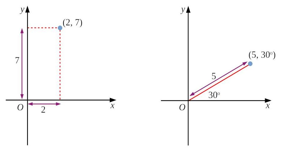
Notice how the point can be described as
Converting Between Systems
Section titled “Converting Between Systems”Here’s where things get interesting: you can move between Cartesian and polar coordinates using basic geometry and trigonometry.
If you have a point at Cartesian coordinates
These formulas emerge naturally from right-triangle trigonometry. The distance
Click to flip • Press Space or Enter
Convert to Polar Coordinates
Extending to Three Dimensions
Section titled “Extending to Three Dimensions”In the real world, we don’t always work in 2D. When we need to describe points in 3D space, we have options:
- Cartesian coordinates expand to
where represents height or depth - Cylindrical coordinates combine polar coordinates in the base plane with height:
- Spherical coordinates use radius and two angles:
For the foundations we’re building here, we focus on the 2D Cartesian system, but knowing these extensions exist is important for advanced mathematics and physics.
Key Takeaways
Section titled “Key Takeaways”What You've Learned
- Cartesian coordinates describe position using perpendicular distances:
- Polar coordinates describe position using distance and angle:
- Both systems pinpoint the same location in different ways
- The conversion formulas
and connect the two systems - These concepts extend to 3D space with cylindrical and spherical coordinates
Understanding coordinate systems is fundamental to mathematics, physics, engineering, and computer graphics. You now have the foundation to recognize when each system is most useful and to convert between them as needed.